
The remains of Oscar Danielson’s irrigation pipes lead to his fields and ditches from the site of the Danielson dam.
In a previous post I published a photograph of swimmers perched on the top rail of the irrigation dam Oscar Danielson built to draw water out of the community canal. This canal redirected some of the flow from Crab Creek towards a number of farms or orchards west of the watercourse. Around 1920 Oscar purchased surplus wire-wrapped wooden water pipes from the city of Seattle to tap into the canal, pumping water from the reservoir behind his wooden dam. His single-stroke gas engine is still hidden in the weeds near the ranch he later occupied on the banks of Lower Crab Creek.

Oscar Danielson mows hay in a field watered by the pipes leading from the Danielson dam. The photograph is probably from the latter half of the 1920s.
The swimmers were part of a larger crowd gathered at the dam for a Fourth of July celebration. It was a custom amongst the farmers and ranchers Continue reading →
Posted in Anthropology, Celebration, Columbia Basin, Crab Creek, Disaster, Family History, Farming, Fourth of July, Genealogy and Family History, Geology, Grant County, History, Irrigation, Native Americans, Natural Disaster, Washington
Tagged A. J. Splawn, Celebrations, Central Washington, Chief Moses, Crab Creek, Culture, Eastern Washington, Education, Family History, Farming, Highway 26, History, Irrigation, Kamiakin, Low Gap, Moses Lake, Native Americans, Nature, Oscar Danielson, Photography, Saddle Mountain, Scablands, Seattle, Washington State

Sandhill cranes frolic in the fields of the Danielson farm, with the Saddle Mountain cliffs looming over it. Photograph by Phyllis Danielson.
The communities of Oso and Darrington were devastated by the recent landslide, in which around fifty houses and more than thirty people were annihilated in the space of a couple of minutes. It will be a long time before life can return to anything like it used to be, with Darrington’s main artery to the rest of the world cut off. Now commuters from Darrington have to head north, past our Sauk River cabin, to get to their jobs, shops and supplies. It takes a lot of time and gas. My son’s scout troop raised cash and supplies that we took to Darrington last weekend, and I’ve been watching the news about the landslide daily.
Pictures of the Oso landslide reminded me very much of the landslide my family and I used to climb around on when I was a kid. One of our favorite hikes was to the cliffs at the top of Saddle Mountain, where you can climb down to a ledge where sandstone exposures have been carved by the winds and graffito-ed by generations of local visitors. Continue reading →
Posted in Cold War, Columbia Basin, Columbia River, Crab Creek, Death, Disaster, Earthquake, Education, Geology, Hanford, Hiking, History, Ice Age flood, Irrigation, Natural Disaster, Saddle Mountain, Science, Washington
Tagged Catastrophe, Central Washington, Climate, Cold War, Columbia Basin, Columbia River, Columbia River basalt, Corfu, Crab Creek, Culture, Darrington, Desert, Dr. Bruce Bjornstad, Eastern Washington, Education, Flood, Geology, Hanford Reach National Monument, Hanford Reservation, History, Ice Age, Lake Missoula, Landslide, Low Gap, Mars, NASA, Nature, Oso, Photography, Saddle Gap, Saddle Mountain, Sauk River, Senator Clarence C. Dill, Sentinel Gap, Stillaguamish River, Washington State, Wenatchee
 Lower Crab Creek provided water. In Eastern Washington, that was a godsend. Temperatures on the Columbia Plateau routinely soar to over 100 degrees Fahrenheit in the summertime, and rain is scarce. Cleaning irrigation ditches with a shovel west of Othello as a boy, many were the prayers I sent for even one scanty cloud to shield me from the overbearing sun.
The Sinkiuse Indians who lived there before me probably shared my distaste for the relentless sun. But they didn’t have the benefit of a well of cold water I could retire to, an air conditioner that cooled the house when I took a break. They were stuck with the weather the way it was: hot in the summertime, cold in the winter. They took a more basic approach to living on the Columbia Plateau: they stuck close to water, or if that weren’t possible, they found the shortest route from one water hole to the next.
Over centuries of migration and travel, humans developed routes that guided them along the most direct lines of travel from one pool or stream of potable water to the next. Continue reading →
Posted in Anthropology, Archaeology, Books, Columbia Basin, Computer, Crab Creek, Family History, Hiking, History, Horses, Ice Age flood, Native Americans, Railroads, Saddle Mountain, Washington, World War II
Tagged Andrew Jackson Splawn, Anthropology, Archaeology, Astor Company, Ben Hutchinson, Beverly, Bridge, British Columbia, Bunchgrass, Burke Museum, Canada, Cariboo Trail, Celilo Falls, Central Washington, Cheat Grass, Chief Joseph, Chief Moses, Chinese, Columbia National Wildlife Refuge, Columbia Plateau, Columbia River, Colville Reservation, Corfu, Corfu Slide, Corfu Switchback, Cow Creek, Coyote Rapids, Crab Creek, Culture, Desert, Eastern Washington, Ellensburg, Environment, Family, Family History, Ferry, Frenchman Hill, Grand Coulee, Highway 26, History, Horses, Hutchinson's Hill, Ice Age, Ice Cave, Immigration, Indians, Kamiakin, Low Gap, Manashtash Ridge, Milwaukee Road, Missoula Flood, Model T, Moses Lake, Mount Adams, Nature, Nez Perce, Okanogan, Oregon, Othello, Perkins Murders, Plateau Indians, Quincy, Railroads, Ranchers, Rattlesnake Springs, Ross Cox, Rustlers, Saddle Gap, Saddle Mountain, Sagebrush, Sam Hutchinson, Seattle, Second World War, Sheriff, Similkameen, Sinkiuse, Taunton, Trails, Vantage, Wahluke, Wanapum, Warden, Washington, Washington State, Washington State Archives, Wenatchee, White Bluffs, World War II, Yakima, Yakima County, Yakima River
-

-
My son investigates the sandstone banks that have weathered out of the basalt cliffs on Saddle Mountain.
-

-
Rust coats the rails where electric trolleys once pulled passenger trains along Saddle Mountain.
-

-
My son enters the upper end of Column Crevice on Saddle Mountain.
-

-
This sportive predator was dashing to and fro across the ridge for quite a while.
-

-
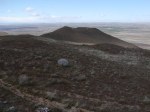
It’s difficult to capture the scale of this landscape.
-
-
As the rest of the mountainside slumped into the flood, this point seems to have resisted.
My grandfather first climbed to the cliffs on Saddle Mountain in the 1920s. He was not the first visitor to a high ledge where soft sandstone is sandwiched between layers of black basalt. Names were carved into the soft rock, dated, gouged deeper on subsequent visits. My father, whose first visit to the cliffs must have been when he was a youngster in the 1920s, introduced the site to his children. Our first visits were made by motor vehicles. Rough trails still exist that can be followed by a truck with high suspension…not that I recommend the method of access. You miss so much when you’re trapped in metal.
My favorite route to the cliffs followed the Milwaukee Road tracks for a mile or so, then veered up the fenceline separating private cultivated land from the BLM sections. After you leave the railroad tracks you start a relentless climb, like going on foot up a mile-long stairway. First you traverse massive slopes of yellow clay, silt that precipitated out of the flood when the waters struck the mountain, slowed and diverted to the east and the west. These banks are composed of countless thin layers. In some places you can find petrified bones, usually blackened vertebrae of fish or small animals. We also found turtle shells and I keep a broken bison bone in my classroom, orange and yellow and imperfectly petrified. Continue reading →
Posted in Anthropology, Archaeology, Biology, Columbia Basin, Crab Creek, Family History, Hiking, History, Ice Age flood, Native Americans, Natural Disaster, Philosophy, Railroads, Saddle Mountain, Science, Speculative History
Tagged Andrew Jackson Splawn, Anthropology, Ben Hutchinson, Bison, British Columbia, Canada, Cariboo, Cavalry, Chief Joseph, Chief Moses, Columbia River, Corfu, Coyote, Coyote Rapids, Crab Creek, Crab Creek National Wildlife Refuge, Custer, Desert, Eastern Washington, Education, Environment, Family, Family History, Flood, Fort Okanaga, Fossils, Frenchman Hill, Geology, Golden Eagle, Hanford Reservation, History, Hudsons Bay Company, Ice Age, Ka-Mi-Akin, Low Gap, Milwaukee Road, Native Americans, Nature, Nez Perce, Oregon, Petrified Wood, Railroads, Rattlesnake Springs, Saddle Mountain, Sam Hutchinson, Sincayuse Indians, Smyrna, Taunton, Trails, Trident Missiles, Wagon Roads, Wanapum Dam, Washington, Washington State, White Bluffs, World War II, Yakima, Yakima County, Yakima Firing Range


