
Recently the last of the Danielsons left the Othello area. The farm I grew up on near Taunton was sold, and the only Danielson thing left is the name of the road it was on, Danielson Road. So many of my articles have featured hikes and experiences from that locale that I thought I should spend a few minutes making clear the features of the area I spent so much time in as I grew up. So consider this a travelogue of sorts, an annotation of the various stories I’ve told, centering on the eastern end of Saddle Mountain, between Corfu and Othello.
THE OTHELLO DIVIDE
Much of the landscape I will be discussing was sculpted into its present form by the last of the Missoula Floods, and probably by a few of the floods before that one. If you’re not familiar with the Missoula Floods, it’s worth doing some background research. There are some really helpful videos and websites that do a much better job explaining them than I will in my thumbnail sketch.
During the Ice Age a glacial lobe swept down the Purcell Trench, past Lake Pend Oreille in Northern Idaho. It dammed the valley of the Clark’s Fork, impounding the waters of the river. The waters rose to form a massive lake in western Montana, flooding the site of present-day Missoula. At the end of the Ice Age, that Ice Dam blew apart, sending the entire lake down the valley, across Eastern Washington. That’s why there are so many rugged canyons and buttes throughout the Columbia Basin. It is estimated that the lake took three days to drain.
As the waters flowed Southwest across Eastern Washington there was nothing to inhibit them until they ran head-on into Saddle Mountain. That occurred about where the town of Othello now sits, and possibly a little to the west. At that point the waters were forced to slow down, allowing silt and ground-up debris carried by the flood to precipitate. This formed clay banks that line the north side of Saddle Mountain from Othello to the west. It’s why I found fish bones in the desert hills behind my home.
Flood waters separated into two separate flows at Othello. One branch flowed southeast to the end of Saddle Mountain and then south to rejoin the rest of the flow. A powerful branch of the flood flowed westward along the north side of Saddle Mountain, undermining the face of the mountain and gouging canyons in the basalt at the base of the ridge. Near Taunton a massive landslide occurred, spilling soil and rock into the retreating flood waters. The silt partially filled in a rock canyon that had previously been gouged into the basalt below the mountain.

Flood waters scoured out the Drumheller Scablands through which Lower Crab Creek flows, and in which my grandfather built his homestead around 1917. After another, much smaller, flood ruined the irrigation project that my grandfather and his neighbors had built, he abandoned the homestead and took up residence on a ranch below the slide area, on the banks of Crab Creek. In the early 1950s my father built his home near Taunton, on property soon to receive water from the Columbia Basin Project. This was the land I grew up on.
CORFU
Taunton, Corfu and Othello were all place names on the Milwaukee Road, which was built along the north face of Saddle Mountain around 1909. Only Othello survives today, although the Taunton substation still stands on private property. In their day, however, Corfu and Taunton served communities around them. When he was building his homestead, my grandfather used to send his shipments from Seattle and Renton by rail to Corfu, where his brother-in-law would pick them up and haul them to the new farm.
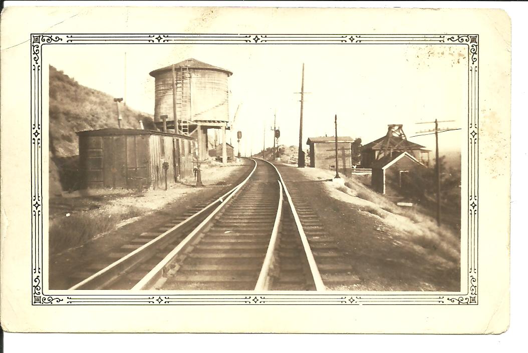
Corfu was a working railroad depot, but it also boasted a number of clapboard houses, a general store and post office, and a fine two-room brick schoolhouse. My father and his brothers attended grade school in the Corfu school. When I was a boy one of my uncles shamefacedly pointed out where he had carved his name onto a doorpost in the schoolhouse. Now, of course, that doorpost is long gone.

Corfu was actually something of a crossroads. The face of Saddle Mountain looms over the townsite to the south. This is what the eastern end of Saddle Mountain originally looked like before the great landslide. At some point a road was cut up the face of the mountain, creating several switchbacks that led to the top of the ridge. The road continued south, eventually reaching the Columbia River at the settlement of White Bluffs. But the road that paralleled Saddle Mountain, passing directly through Corfu, was the only highway to the west. My father once referred to it as “the Seattle highway.” It led through all the railroad settlements along Lower Crab Creek, and then it trended north along the Columbia to the Vantage Ferry.

Taunton was a less developed settlement. Three company homes stood in a line west of the substation. There were no stores or post office. There was an elementary school located on the flats north of the railroad. It was an ample clapboard building, which still stands today. It is not, however at Taunton. The schoolhouse was moved into Othello and repurposed as a rental duplex. Several of my father’s siblings attended school at Taunton.
THE WESTERN SLIDE AREA
Just east of the Corfu townsite the Slide begins. The area just east of Corfu was the only place in the entire slide area where the top of Saddle Mountain was breached. A portion of the top of the ridge collapsed, leaving a saddle-shaped pass. This feature provided the name of the entire Saddle Mountain Range. Filled with rubble and detritus, Saddle Gap didn’t provide a good route for crossing the mountain. But the relatively broad, smooth and level area to the west, above the gap, was an inviting site. From that area you have a broad view of all the Crab Creek Valley to the north, and you can easily reach an overview of the Columbia River Valley to the south.
Because of its overlook, the place was chosen as the site of the first Columbia Basin Project picnic in August of 1927. The event was a celebration of the successful passing of a congressional bill to study the feasibility of damming Grand Coulee and sending irrigation water across a wide swath of farmlands to the south. The idea had been kicking around since Rufus Woods of the Wenatchee World published an article by Billy Clapp in 1918. It had gained the backing of Senator C. C. Dill and a bevy of other politicians. Woods, Dill, the governor and a number of other dignitaries hosted the picnic at Saddle Gap to officially announce the beginning of the Columbia Basin Project. No doubt they gestured at the vast lands to the north and pronounced that the desert would soon bloom.

Fifty years after the 1927 picnic another picnic was held at the same site, to celebrate the first picnic. My grandfather and his family attended the first picnic, dining on baked potates and watermelon. I attended the later picnic with my father and family. Baked potatoes and watermelon were on the menu.
During and after World War II, the ridge top of Saddle Mountain marked the northern boundary of the Hanford Reserve. A dirt road follows most of the crest of the mountain in both directions from Saddle Gap. After the war radar was installed on the mountain south of Othello, and a missile installation was built near Saddle Gap. Remains of the site are still visible. In the 1960s it was still illegal to fly over the Hanford Reserve in a private plane. Once an uncle of mine drove his kids and some of my family to the road at the top of the ridge. We were surprised by a low-flying airplane seeking to cross the mountain through the Taunton Pass without being detected by government radar.

Indigenous people living in this region long ago established their traditional routes across the mountain. Depending on where they wanted to go, their trails led to one or another footpath passes over the ridge. But always these trail led from water to water, and in this region that meant that the trails led to and from Crab Creek and the Columbia River. On the tumbled hummocks of a broad slope to the east of Saddle Gap you can find traces of these ancient trails. One leads to a shelf on the mountain face that I called Gooseberry Terrace. It’s a steep climb at almost a forty-five degree angle up the north face of the mountain, and on a hot summer day it would have been exhausting. But there is shade at Gooseberry Terrace, and, of course, there are gooseberries. The bushes must have been planted by people, whether intentionally or not. The trail leads farther up the ridge and over the mountain from that point. Other footpaths converge on what is probably the lowest pass through this section of the mountain, which I labeled Footpath Pass on the Lidar image.
THE PROMONTORY
In the middle of the slide area stands a pyramid-shaped peak looming over the destruction. For whatever reason, this relic of the original mountainside stood firm while the mountain collapsed around it. The Promontory provides another good overlook of the Lower Crab Creek valley. Its slopes may also provide tiny lumps of obsidian.

COLUMN CREVICE
At the margin of the ridge top, where the smooth original mountaintop gives way to the tumbled remains of the slide, there are cracks in the side of the mountain where the slide stopped moving before the slumping contours of the hillside dropped away. Over the 12,000 years since this slide occurred, silt has partially filled in the floor of one of these cracks, providing a convenient trail through a crevice that is some six to eight feet deep. My brother christened this feature Column Crevice, for the exposed basalt columns that line it on both sides.

Column Crevice isn’t on any trails, and you sometimes have to search for it to find it. As a relic of the slide, though, it provides silent testimony to the forces that ripped the face off the mountain. One has to imagine what it must have been like when the entire slope below the crevice was undulating, pitching and plunging.


THE CLIFFS
Another feature of the east end of the slide area is a place where the collapse of the mountainside was so abrupt that it left a soaring escarpment behind. The cliffs provide access to the same layers of sediment and successive basalt flows that one can trace on the face of the mountain farther west, between Smyrna and Beverly. Long ago, someone discovered a ledge near the top of this escarpment where an exposed block of the Ringgold Formation is easily accessible.

This ledge became a magnet for boys growing up in the area, as I can attest. Not only was my dad’s name carved into that block, dated 1923, but the names of each of my brothers and several cousins also appeared. Erosion has erased most of those carvings, and soon all of them must disappear. For me, the ledge was a destination. It provided a convenient end point for my after-school hikes. I would throw my backpack into the house after the bus dropped me off, I’d fill a canteen with water, and off I would go. I would hike along the railroad tracks over the two coulees to the west of Taunton and then set off up the steep hill on the west side of the fences that marked the boundaries of the fruit orchards.
THE AMPHITHEATER
The first landmark to be encountered was a feature we called the Amphitheater. This was a huge scoop of earth that had slid away, leaving behind a perfect performance site. The only actors besides us were coyotes and jackrabbits, though. Over the centuries the uphill face of the Amphitheater had been worn into shelving parallel trails tracing horizontally from one edge to the other. The trails were perfect for seating an audience of thousands, but usually I was alone when I went through the Amphitheater.
TAUNTON PASS
In several of my articles I reference the pass over Saddle Mountain that was used by wagons. This same pass provided the Hudson’s Bay Company its route to the Okanogan and the army the trail to Fort Chelan. It was this pass that allowed the army to drag the steamboat Chelan over the mountain on its way to the upper Columbia River. I know my father and his family used the pass when they needed to go to White Bluffs or Hanford in the days before those towns were eliminated by the army. Even today a bumpy dirt road climbs the north face of the pass to reach the road that follows the top of the ridge. Traces of the trails and roads are gouged into the face of the mountain here. The u-shaped contour of a wagon road follows roughly the same route as footpaths. On the south, these trails and roads led towards settlements along the Columbia River. On the north, though, they all trend towards the coulees west of Taunton. Before the Milwaukee Road filled in their trestles with gravel, the wagon roads were still traceable until they reached plowed fields beyond the coulee.

Much of the land I have written about in this article is under the administration of the Bureau of Land Management (BLM). Some of it borders on or crosses privately owned property. As a boy I didn’t understand the dangers of hiking on a railroad right-of-way until I found myself in the middle of the tracks as a freight train suddenly appeared a few hundred yards down the tracks. The clay walls of the railroad cuts had absorbed all sound of the approaching train. I learned quickly. Access to the top of Saddle Mountain is now easiest from the south. Paved roads can take you to the ridge top south of Saddle Gap. I haven’t explored access to the slide area from the south, but the old Corfu highway provides access on the north side of the mountain.

Fascinating stuff. I’d love to explore the top of Saddle Mtn. in my pickup if the road(s) is accessible.
I have some very specific 55+ years experience with one exact area along the Saddle Mountain range at the Smyrna Ice Cave location.
There is more information I would like to share about discoveries I came upon regarding pre-European Native American activity.
I’d be interested in what you have to share. There is a lot that’s forgotten about this area.
Thank you Mark for the wonderful history of the Corfu and Taunton area. I no idea! I’m sorry I wasn’t more interested in these things when I was growing up in the area. I hope all is well with you and your family. And come to the next HS Reunion!!!!
Vicki Gearheart Paxton
I lived in Othello from the 1950’s until the early 1970’s. My father worked for the Bureau of Reclamation and I started my career with the Milwaukee Road here. As a teenager I explored the Crab Creek area and climbed the Saddle Mountain to the Saddle Gap. Also found the ice caves on the north side of Saddle Mountain. I hunted for arrow heads along Crab Creek and found an obsidian arrow head where Crab Creek flows in to the Columbia River. Great place for a kid growing up. The history of this area is so interesting. Thanks for sharing. The Danielson family was so much a part of the history.