“The U.S. Bureau of Reclamation and the Department of Ecology have completed an appraisal level study of potential Columbia River mainstem off-channel storage sites…The appraisal study determined that the Crab Creek site represents a potentially viable reservoir location. This site appears to be preferable to the Hawk Creek site based on both cost and technical feasibility criteria.” From Columbia River Basin Storage Options – Columbia River Mainstem, Department of Ecology web page.

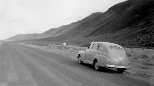
A brief stop on a car tour of the Crab Creek Highway in the late 1940s. This is near the location where the Department of Ecology and the Bureau of Reclamation would like to place a dam 250 feet high and a mile and a half wide.
The government is back in the dam building business. This time it looks like they’re going to dam Crab Creek! There are only two sites currently under consideration for a new water storage (and possible power generation) facility off the main channel of the Columbia River in Washington State. The results of the preliminary study favor damming Lower Crab Creek to create a reservoir that inundates the entire valley, from an earth core dam 250 feet high near Beverly to high water shorelines near Taunton. If you’ve spent any time on this blog, you can be sure I have deep reservations about building such a dam and flooding what I consider to be unique historical, cultural and environmental landscapes.
My family is perhaps lucky in this situation. Although the new lake created by the Crab Creek Dam would cover our ancestral homestead and the ranch that succeeded it, the more recent Danielson spread appears to be right about at the shoreline. But when the new lake is created, other infrastructure will have to be altered. It looks as though a massive power line will cut down Danielson Road, looming over the house I grew up in.

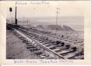
This view of the Lower Crab Creek valley, taken in the early 1950s (as my father notes: before irrigation), shows what will be a lake if the dam is built.
Will it happen? I don’t know. In this day of budget crisis funding may be difficult to pry out of the government. But who knows whether a Roosevelt-style public works program might not use the dam project as a solution to the economic slump. It’s the type of program that stands a chance of succeeding: employment of a vast range of professional and working types, new power generation, new irrigation storage, amelioration of a certain habitat (albeit at the cost of destroying other more unique habitat), benefits to local industries and those further afield. It might even help to restore the aquifer depleted by injudicious permission to pump water for irrigation circles. Continue reading →
Posted in Anthropology, Archaeology, Biology, Botany, Columbia Basin, Crab Creek, Education, Geology, History, Ice Age flood, Native Americans, Railroads, Saddle Mountain, Science, Washington, World War II
Tagged A. J. Splawn, Anthropology, Archaeology, Ben Hutchinson, Beverly, Clovis, Columbia National Wildlife Refuge, Columbia River, Corfu, Crab Creek, Crab Creek Dam, Culture, Danielson Road, Desert, East Wenatchee, Eastern Washington, Education, Environment, Family, Flood, Geology, History, Ice Age, Ice Cave, Jericho, Kamiakin, Kennewick Man, Lind Coulee, Marmes Rock Shelter, Milwaukee Road, Missoula Flood, Native Americans, Nature, Petroglyphs, Pygmy Rabbit, Railroads, Red Rock Canyon, Rock shelters, Saddle Mountain, Sandhill Cranes, Second World War, Smyrna, Taunton, U.S. Bureau of Reclamation, Washington, Washington State, Washington State Department of Ecology, World War II


