Tag Archives: History

All in the Family

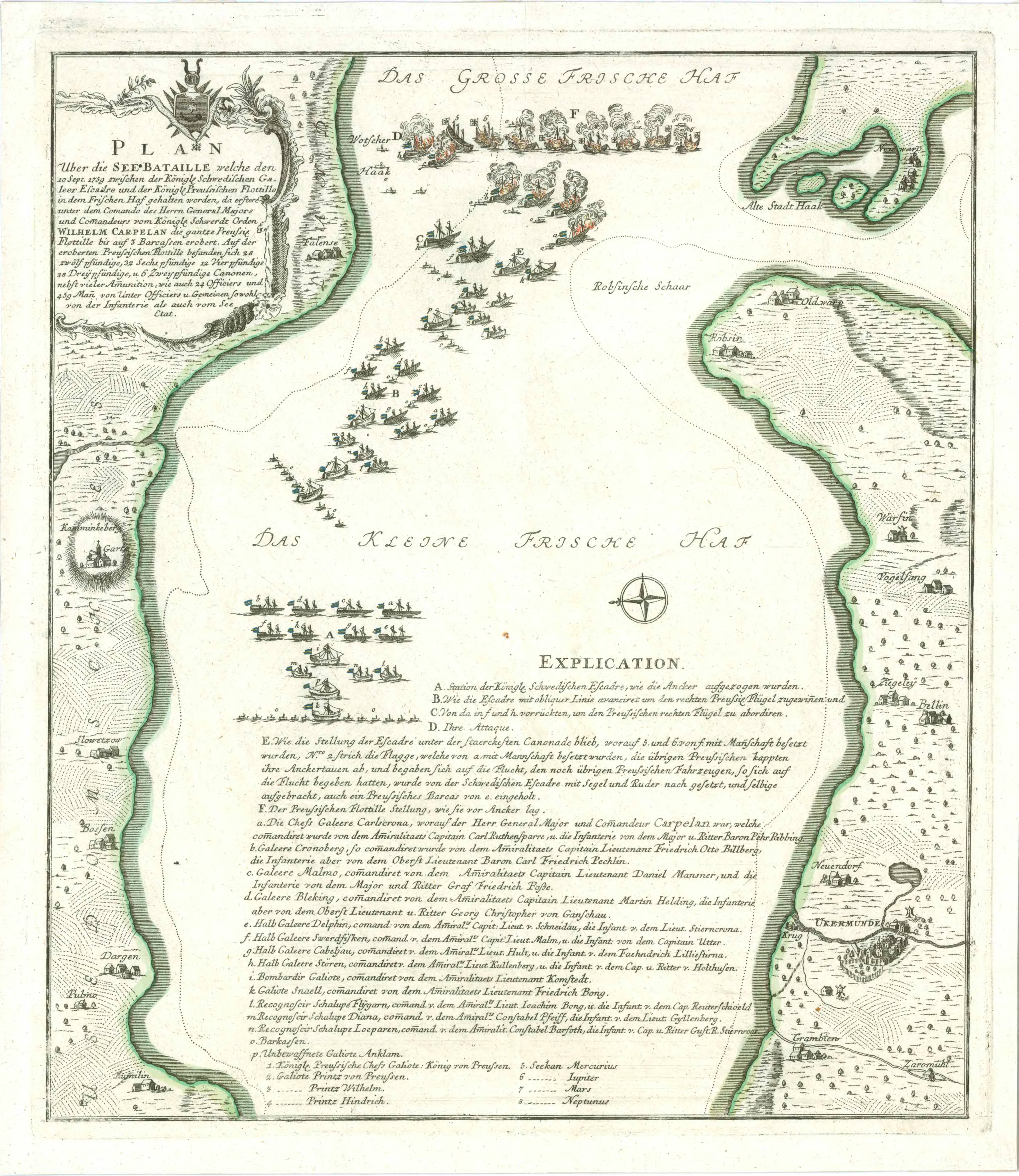
In 1759, an imperialist Sweden, with the aid of their Russian allies, sought to regain lost territory in the region of Prussia known as Pomerania. It was one of many actions in the Seven Years War, a war originally precipitated by an unknown militia officer from Virginia named George Washington. The particular action I am interested in here was a lopsided contest between the Swedish fleet and that of the Prussians, who were defending their independence against their former rulers.

The scene of this contest was a large bay at the mouth of what we now call the Oder River, which the Germans called Stettiner Haff. The Swedish fleet, under Karl Ruthensparre, had penetrated the bay in the early days of August, forcing the retreat of a tiny makeshift Prussian fleet on August 22. But the Prussians rejected the idea of surrender. They gathered fishing boats and cargo scows which they hastily converted into warships. By September 10, they were ready to face the Swedish again.

In our imagination, such encounters were between massive sailing vessels with roaring cannons on many decks. But that wasn’t the case here. The bay was too small for ships of the line. Instead, most of the ships that faced each other relied on oar power. They were galleys or galiots (small ships who could use sails or oars), much like those that fought in the Mediterranean in Greek and Roman wars. Even the gunboats, though equipped with sail as well, used men with oars to maneuver. Of course, the guns made all the difference.

The Swedish fleet that day was commanded by Wilhelm von Carpellan, who arranged his vessels in four lines to meet the enemy. First was a line of four powerful galleys equipped with 13 guns each. They were followed by a line of four demi-galleys, each bearing five guns. These were galleys equipped with sails, but I’m not exactly sure how they differed from the galiots. They were probably larger. The third line contained three sloops, powered by sail, and the only actual ship. It was equipped with howitzers that could lob shells onto the enemy over the heads of the friendly ships ahead of it. Finally, there was a line of thirteen gunboats, oar powered, but with sails available. The gunboats carried only one or two guns, and they had to be maneuvered by oar to aim the shots.

The doughty Prussians came out to face this force with their four galiots and four galleys armed with twelve cannons each. They bolstered this force with five canonnières, shallow water boats carrying less powerful weapons, more suited to use on a lake or river.

You can guess how the battle turned out, even though three of the Swedish demi-galleys and nine gunboats were dispatched to deal with some unknown sails to the south before the battle commenced. Those unknown sails belonged to neutrals, but the Swedish force had been reduced by the distraction.

The Prussians were profoundly beaten: two galleys and two galiots sunk, two galleys, two galiots and one gunboat captured, 490 men taken prisoner and 30 killed or wounded. The Swedes didn’t go unscathed. Officially, one of their gunboats was sunk and 44 men were killed or wounded. Unofficially, though, the toll was somewhat higher.

What brings me to investigate this event is some family history research I’ve been doing. It appears that I have at least three direct ancestors in this battle, two of whom died later as result of the wounds they sustained there. They were all three oarsmen for some of the galleys, galiots, gunboats or demi-galleys, but I haven’t been able to identify which vessels they served on.

All three were members of a sea-going coast guard that traditionally defended the coasts of the Swedish homeland. Two of them actually served in the same unit, and they knew each other from home. The third came from a province in the interior of south central Sweden. Their descendants eventually intermarried and eventually their descendants produced my grandmother.

The oldest of these three men was named Olof Olofsson. As you might guess, it’s a common name in Sweden. I don’t have any birth records for him, so I’ve calculated his age from the date of his marriage. I estimate that he was in his fifties, or even his sixties, when he participated in the battle. He had enlisted in the Swedish Coast Fleet as a båtsman, basically, an oarsman on one of those galleys. Since there are so many common names like his, when he joined up he was assigned a new surname. He became Olof Olofsson Frimodig. This was a common practice in the Swedish military, and the new names were even assigned to certain service numbers, just waiting for young men to take them. My grandfather’s brother spent the remainder of his life as Elmquist, although he was just as much a Danielson as my grandfather was.

The second ancestor involved in this episode was named Olof Olofsson. Sound familiar? He hailed from the region of Ångermanland, and fleet records happen to mention that he was born in 1723. The two men were not related by birth, but they knew each other. This Olof became Olof Olofsson Dunder. This is a name I am proud of, since television evidence clearly links my family to The Office (Dunder Mifflin). Both Olof Olofssons joined the Swedish Coast fleet from the province of Västernorrland, located north of Stockholm. The first one, Frimodig, was my sixth great-grandfather (seven generations from me), and the younger Olof was my fifth great-grandfather. It’s not hard to imagine that in a place as sparsely populated as Ångermanland that the two men might become related by marriage. And, in fact, the younger Olof married the daughter of the older man.

The third man was born in the central Sweden province of Jönköping in 1712. He eventually joined the Coast Fleet as well, as part of the Northern Rosslags Company. He adopted a service name that made him into Israel Olofsson Luthström. Both Luthström and Dunder are fifth great-grandfathers of mine. Their grandchildren married to produce the ancestors of my grandmother.

None of these men died in the battle of September 10, 1759, but Luthström and Frimodig were both grievously wounded. Both of their records indicate that they were sent to something called “Barraquerne,” which might be a hospital or a vessel designated to treat the wounded. Luthström died there on November 19. Frimodig had already passed away on the 14th of November.

You might remember that I said the official Swedish death toll for the battle was 44 killed or wounded. I doubt the accuracy of that number. In the company in which Dunder and Frimodig served there were at least 67 men who perished between October 1759 and January 1760. Most, if not all, of these must have been wounded at the Battle of Stettiner Haff. That is the toll for only one company of all those that served in the battle.

Olof Olofsson Dunder was not listed as wounded, although I would be surprised if he hadn’t served on the same vessel as his father-in-law. He lived on to perish in what I presume was a different action, possibly in Finland, in 1775. Church records in his home parish noted his death on May 28th of that year, but make it clear that he died somewhere else.

These men died in an action that is almost entirely forgotten today. The Pomeranian Campaign ended up gaining nothing permanent: Pomerania remained German. Sixty miles west of the place of battle is a small German town called Barth, which in World War 2 was the site of Stalag Luft 1, a prison camp for captured Allied Airmen. A couple of generations earlier, in 1872, my German great-grandmother was born there. Perhaps her ancestors crewed the Prussian boats in their hopeless resistance to the Swedes.

It’s all in the family.

The Earth Drum

The angled trace of an ancient footpath rises to a hollow at the top of Saddle Mountain. Gooseberries growing in the hollow may indicate that people used to take a break there on their journey to and from the Columbia River on the far side of the ridge. The trail leads from the river to Crab Creek on the north side of Saddle Mountain.

I spent many days wandering the hills and plains around Lower Crab Creek when I was young. It’s one of the things I miss, living now on the wet side of the state. I have always said that the desert is an honest land. It displays the record of everything that happens there, and the record remains visible sometimes for centuries, if you know where to look.

There is a gravel road leading into the Columbia Wildlife Refuge that goes almost straight north from the highway. Once as a young man I hiked along that road. Noting something in the weeds, I left the gravel and headed toward a rock outcrop. I was partway there when I came upon a u-shaped rut, familiar to me because I had once camped in such a rut on Saddle Mountain. This was the extension of that same wagon trail, paralleling the gravel road, headed toward the Crab Creek crossing. It was part of the wagon road leading from White Bluffs to the Grand Coulee Country, the same trail Ben Hutchinson helped drag the steamboat Chelan over. And steps away from the wagon road was a trench barely a foot across, tending in the same direction, from water to water. This was the footpath Native Americans had used for millenia before they guided the Hudsons Bay Company trappers along it on their way to Okanogan.

Three roads north, in parallel. People had the same idea in different generations, and the desert remembers.

A LIDAR image of land north of Highway 26 reveals the Refuge access road, flanked on the left by two faint wagon traces that can be followed to the mouth of Taunton Coulee, and through Low Gap on Saddle Mountain. The one closest to the access road is probably the remains of the main trail towards the Okanogan country.
Continue reading

Donny Boy

My great uncle, Gus Norberg, took this photograph of Donny Boy #1 when he visited the site in 1934.

Paging through the old picture album my dad put together as a young man, one photograph always stood out as somewhat incongruous. A derrick rises at the far end of a dusty parking lot. A number of old cars cluster around the base of the structure. On the back of the photograph is an address written in blue ink, describing the home of B.G. Norberg in Seattle. Bror Gustaf Norberg was my grandmother’s brother and a frequent helper on my grandfather’s farm from 1917 on. Gus carried a camera with him and he took many of the photos I have used in these articles. I don’t know for certain just when Gus Norberg took the photograph, but it’s possible that he was in attendance at the opening of the new oil well, dedicated on December 2, 1934. The well was located on the eastern end of Frenchman Hill, on the slope above the present-day Mar-Don Resort.

The People’s Gas and Oil Development Company began work on their test well, Donny Boy #1, in 1934. Over the next four years the well reached a depth of 4,575 feet, but it produced little of interest. According to Deputy Oil and Gas Supervisor of the state’s Division of Mines and Geology, Vaughn E. Livingston, Jr., who responded to my query in November of 1970, Donny Boy produced only a slight gas showing and a tar-like oil. Livingston went on to say that the gas showing was probably legitimate, but that he seriously questioned the oil show. He also complained that the people who drilled the hole were lax in their record-keeping and that, in 1970, the state knew nothing more about the well and its production.

Perhaps the company just didn’t understand the requirements. They did keep records, reporting descriptions of equipment being used, names of employees and the depth of the well over the course of its four-year operation. In 1977 a V. G. Matthews donated the records to the Washington State University Libraries, where they are available today. In all, there are three boxes of daily drilling reports and three boxes of daily shot drilling reports. The boxes take up three linear feet of the shelves of the Manuscripts, Archives, and Special Collections in Pullman.

The Wenatchee World newspaper ran an article about the “Spudding In” of Donny Boy #1 the day after the event. The article provides details about the mechanical operation of the drill. The article ran on the front page of the paper. Reproduction courtesy of North Cascades Regional Library, Wenatchee.

Without having seen those records, I can’t say whether there was a difference in methods of drilling. Shot drilling, I assume, is what is today know as percussive drilling. In this technique, a bit attached to a cable is lowered into the hole and it is used to loosen soil and rock at the bottom of the hole. Periodically, the bit is removed and soil is extracted using a bailer, or the contents are pumped to the surface if the cuttings are suspended in water. It’s possible that this method was being used from the beginning of the operation and that only the recording methods changed. The term “Shot drilling” wasn’t used until January 3, 1936. But the Daily Drilling Reports evidently also continued until the summer of 1937, so for a year and a half both types of records being produced.

Oil exploration began in Washington around 1900, when the first exploratory well was drilled in the state. Since then there have been 7,540 recorded oil and gas leases issued in the state. All of them have been closed and there is no petroleum being extracted at this time. But in the early 1930s there were people willing to speculate on the chance that there was something in the rocks beneath Eastern Washington. And much of the speculation was taking place in Benton County. The first exploratory well drilled there dated to 1912, and by the time the Donny Boy #1 operation commenced there had been 30 wells drilled in Benton County. It was one of the few areas where a product was actually extracted, but that wasn’t until 1957. So, out of the 30 wells, 13 of the Benton County wells were considered dry, or produced only water. Four wells reported small quantities of gas, and 14 produced gas, but probably not enough to make the operations profitable.

Profit was the motive, of course. You can find original People’s Oil & Gas Development Company stock certificates on sale in antique stock and bond dealerships. I doubt that there was a great return on the original investments.

I have not tried to explore the area of Donny Boy #1 on foot to find its precise location but using Google Earth I have found some suspicious-looking disturbances on the soil. It is possible that these mark the position of the well itself and perhaps some storage facilities. In my great-uncle’s photograph, the sun seems to be shining strongly from the left. If this Google Earth image represents Donny Boy #1, Gus took his photograph in the morning, looking south towards the well from a position to the right of the remains in this picture.

Murder

This portrait of Wild Goose Bill was published in the Spokane Chronicle in 1934 and was based on an image discovered in the offices of Wilbur's local paper.

This portrait of Wild Goose Bill was published in the Spokane Chronicle in 1934 and was based on an image discovered in the offices of Wilbur’s local paper.

On the 25th of January, 1895, two men rode a freight wagon along a frozen road leading out of the town of Wilbur. The heavy wheels smashed through frozen puddles and left deep ruts in three feet of snow. Clouds of steam ghosted behind the men and the horse, suspended in the still air. A ceiling of oyster-colored cloud sealed the sky, stained by the weak glow of a sun powerless to penetrate. Few words were uttered, and the men’s faces were set in anger or determination.

It was age pursuing youth that led to this moment, a timeless theme played out this time in the fading days of the American west. One man was realizing that the days ahead featured nothing but old age, that the world no longer saw him as strong and powerful. His dreams of a young wife had been shattered. His days of legend were behind him. On this day the final act of his legendary life was to be played out.

Samuel Wilbur Condit was born in New Jersey, but followed the lure of gold to California. Even as a teenager he was smart enough to recognize that the real money in a gold rush would be found in supplying miners with the goods they needed. Continue reading

The Customary Celebration on Lower Crab Creek

The remains of Oscar Danielson's irrigation pipes lead to his fields and ditches from the site of the Danielson dam.

The remains of Oscar Danielson’s irrigation pipes lead to his fields and ditches from the site of the Danielson dam.

In a previous post I published a photograph of swimmers perched on the top rail of the irrigation dam Oscar Danielson built to draw water out of the community canal. This canal redirected some of the flow from Crab Creek towards a number of farms or orchards west of the watercourse. Around 1920 Oscar purchased surplus wire-wrapped wooden water pipes from the city of Seattle to tap into the canal, pumping water from the reservoir behind his wooden dam. His single-stroke gas engine is still hidden in the weeds near the ranch he later occupied on the banks of Lower Crab Creek.

Oscar Danielson on his Crab Creek farm in Grant County, WA, circa 1920

Oscar Danielson mows hay in a field watered by the pipes leading from the Danielson dam. The photograph is probably from the latter half of the 1920s.

The swimmers were part of a larger crowd gathered at the dam for a Fourth of July celebration. It was a custom amongst the farmers and ranchers Continue reading

The Day the Mountain Came to Town

The view of Mount Saint Helens from the summit of Mount Adams on July 4, 1976.

The view of Mount Saint Helens from the summit of Mount Adams on July 4, 1976.

On the 200th anniversary of our country’s birth my cousin Dale and I joined one of the last mass climbs of Mount Adams in south-central Washington. I left from work on the Friday afternoon, drove to Yakima to pick him up, and we went to a campground outside Trout Lake to spend the night. Of course the excitement and the noise of all the other campers kept us awake all night. I don’t remember getting any sleep at all.

We were rousted out for the climb around 3:00 in the morning. We received some orientation and instructions and lined up to begin the climb. One of the instructions was to stay in line and not to pass those ahead of us. We were young and strong. Many of those ahead of us were neither, so the temptation  to violate that rule was strong.

We reached tree-line just before dawn, and that morning provided one of the most spectacular views I will ever see. We watched the ghostly pale peak of Mount Saint Helens emerge from the night, turning raspberry pink, then dazzling white. Before it erupted, Saint Helens was nearly perfectly symmetrical. As we strapped on our crampons and struggled to keep our places in line, we watched Mount Saint Helens in the distance, a graceful and beautiful mountain that later proved to be powerful and dangerous. Continue reading

Fu-Go, or How Geologists Fought off the Japanese Attack on North America, although the Threat Remains

The tail of an unexploded Japanese balloon bomb protrudes above the mossy forest floor near Lumy, British Columbia.

The tail of an unexploded Japanese balloon bomb protrudes above the mossy forest floor near Lumby, British Columbia. This photograph is courtesy of Infonews.ca, which published a story about the bomb on October 10, 2014.

On November 3, 1944, the Imperial Japanese Army attacked North America, and they did it from three Honshu beachheads. It was on that date that the first of some 9,000 balloons, fitted with incendiary and high explosive bombs on a three-day timer, were lofted into the recently-discovered jet stream. The innovative form of aggression spread dangerous explosives across a huge swath of North American territory, from Alaska to Mexico, from the Pacific Coast to Detroit, Michigan. Fewer than 250 of these balloons have been accounted for, although an estimated 1,ooo balloons may have made it across the Pacific. While most of the 9,000 probably failed to reach American shores, those that made the crossing and went undiscovered might still pose risks to the unsuspecting.

Foresters working near Lumby, British Columbia, made the most recent discovery of unexploded Japanese bombs in October of last year. Hikers and people who work in wild places should be wary of undiscovered explosives from these balloons.

When Japanese balloon bombs, known as Fu-Go to their makers, first began to arrive in America, authorities mistakenly thought that the devices were being launched from submarines surfacing near our coasts or that they had been built in Prisoner-of-War camps along the coast. Continue reading

Remember This

Weeping Willow and Loansome Hart left photographs of themselves inside a banjo ukulele, as a gentle "Remember Us."

Weeping Willow and Loansome Hart left photographs of themselves inside a banjo ukulele, as a gentle “Remember Us.”

My family has long had a close relationship to the making of music. If you go back far enough in my mother’s family, we were probably connected to the German composer of operas and organ music, Johann Georg Kühnhausen, whose Matthäus-Passion (Saint Matthew’s Passion) is still occasionally performed. But for the most part, we played much more informally.

My father and several of his buddies toured around Eastern Washington in the 1930s and 1940s, playing dances in little towns like Othello and White Bluffs as the Five Jives. Two of his brothers were members of a long-lasting semi-professional band that formed under Steve Laughery in Moses Lake and which continued to tour the west after Laughery died in a landslide. The memory of these bands survive in some of the artifacts we still possess, some sheet music inscribed with “Five Jives” and a couple of vinyl albums from the Many Sounds of Nine, my uncles’ band. I have written before about the old violin my father used to play, passed on to him from one of my mother’s uncles. I use it to play dance music in a couple of contra-dance bands in Northwestern Washington now.

There are no markings on the instrument to indicate how old it it. The name "Elton" is stamped on the metal resonator ring.

There are no markings on the instrument to indicate how old it it. The name “Elton” is stamped on the metal resonator ring.

Last month I found a very interesting instrument, seemingly meant for me. It had a peculiar back story and it fit a special niche in a musician’s repertoire. For there will always be a time when you want to create the most annoying sound you can musically make. In this case, with a banjo ukulele. Continue reading

All the Warning We’ll Get

The Saddle Mountain Fault scenario envisions an 87-mile long failure of the fault.

The Saddle Mountain Fault scenario envisions an 87-mile long failure of the fault.

There was a small earthquake centered on Frenchman Hill one day around 1972. When an earthquake scientist from the University of Washington called Othello High School to look for a reliable  student to tend to a helicorder they were setting up at the epicenter, they ended up talking to my mother, the counselor. I was 16, and I had just gotten my driver’s license. She told them she had a perfect match for them.

So my second job off the home place (the first one was changing sprinklers for my neighbor) was visiting a tiny trailer parked next to a plowed field overlooking the Lower Crab Creek valley and the ancient massive slide on the north face of Saddle Mountain. Six seismographs fed streams of data to a series of heated needles that recorded every tremble of the earth around the trailer. I had to changed the waxed paper they burned their message onto once a day and then put in a phone call to Colorado to calibrate the clock with the National Bureau of Standards.

Although I didn’t know it at the time, this must have been a heady period for earthquake scientists in the Northwest. Endorsement of the theory of plate tectonics was in its infancy. Continue reading

Coconut

Sam Hutchinson looms over another man, possibly Hugh Dunlop in this photograph from an unidentified historical archive.

Sam Hutchinson looms over another man, possibly Hugh Dunlop in this photograph from an unidentified historical archive.

When my brothers were old enough to drive it wasn’t uncommon for several of us to pile into a car and head out into the Potholes to fish, swim or hike. We liked swimming in a certain hole in Hayes Creek. A favorite fishing spot was Hutchinson Lake, where red basalt cliffs rimmed the cool greenish waters. Even at that age, my father had told me plenty of stories about the Hutchinson brothers. My imagination placed old Sam Hutchinson on those clifftops, dressed in a black lawman’s cutaway coat and a flat-rimmed hat. Taller than seven feet, he once rode over those hills and lived in a cabin not far from where the lake is found.

Perhaps it was this image that inspired me to wander while my brother fished for those big trout that rarely got caught. I trudged out into the brush north of the lake looking for anything that might have been dropped by old Sam and he rode out one day. I found crushed and rusty tin cans, flaking apart. There were the remains of wire fencing smashed into the earth. Bits of purpled glass sparkled at me through the cheat grass. Then I found a rut. Continue reading